STORM MOUNTAIN DIAMONDS (Pty)Ltd

KAO Mine
Geology
Kao Mine Geology
The primary sources of diamonds are volcanic rock types called kimberlites and lamproites that are located on or around the margins of ancient (older than 2,600,000 million years), stable land masses known as cratons. On cratons, diamondiferous kimberlites and lamproites have deep seated origins, beyond 150 km depths where the extreme pressures and temperatures enable diamonds to reside before being transported rapidly to the Earth’s surface by these unusual and rare magmas in the form of narrow dykes and irregular to oval shaped pipes. There are no active, diamond-bearing kimberlite nor lamproite volcanoes today and thus all of the approximately 10,000 known kimberlite and lamproite bodies are essentially ancient (fossil) forming part of Earth’s geological record.
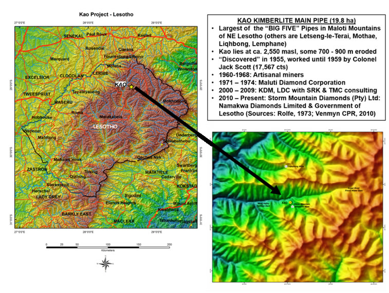
In Africa, all of the economic primary diamond sources known to date are kimberlites – the best known of which are those associated with the Kaapvaal craton of southern Africa. These include such famous pipes as Cullinan (Premier), Venetia, Kimberley Pool, Finsch, Koffiefonein and Jagersfontein in South Africa and Jwaneng, Orapa, Letlhakane and Karowe mines in Botswana. The small Kingdom of Lesotho, situated on the south-eastern corner of the Kaapvaal craton, is also up with its larger neighbours where - of its 5 kimberlite pipes high up in the Maluti Mountains - 4 are operational mines, viz., Kao (19.8 ha), Letšeng-le-Terae (Main Pipe 17.2 ha and Satellite Pipe 5.2 ha), Mothae (8.8 ha) and Liqhobong (8.5 ha). Moreover, some of the largest and highest quality diamonds known have been are recovered from these Lesotho pipes, in particular, Letšeng-le-Terae which is famous for its top white Type IIa stones and Kao which consistently yields high quality pink Type IIa diamonds.
KAO Kimberlite Pipes and Some History of the Main Pipe Development
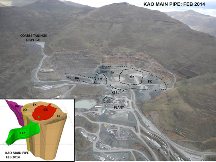
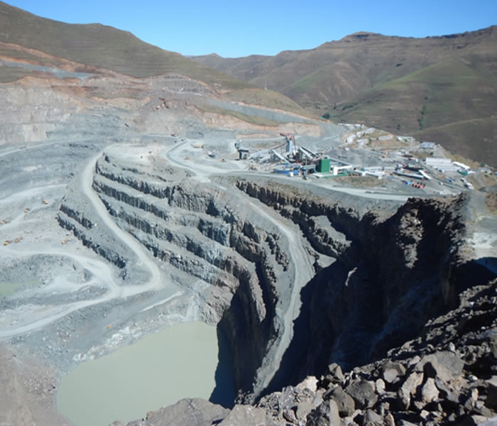
At Kao (Figure 1), there are two Cretaceous-age kimberlite pipes, a larger Main Pipe of 19.8 ha and a smaller Satellite Pipe of 3.2 ha, that form part of the Lemphane – Roberts belt of kimberlites in the Maluti Mountains of northern Lesotho that intruded the ca. 180 million year (Ma), Jurassic-age Lesotho Formation (Drakensberg) basalts some 90 Ma ago. In spite of some 750+ m of erosion, the Kao Main Pipe is the largest known kimberlite pipe in the Group 1 Lesotho Kimberlite Province which is affiliated to the Kimberley and Gordonia Kimberlite Provinces of South Africa.
At 19.8 ha, Kao Main Pipe is the 4th largest economic kimberlite in southern Africa but only 1.1 ha is high grade at ca. 18 carats per hundred tonnes, cpht. The remainder of this irregular, oval pipe is low grade, in the order of 4 – 7 cpht, making it economically-marginal by global standards and it has taken some 60+ years to bring Kao Main Pipe into a full-scale, operational primary (kimberlite) diamond mine! Some history getting there….
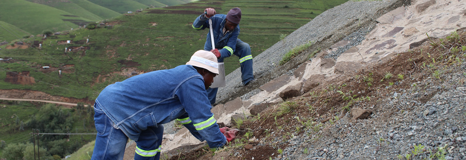
Although the Kao kimberlites were known to the local citizens as a source of “sekama” (ilmenite for body decoration) prior to the mid-1950s, the kimberlitic and diamond-bearing status of the Main Pipe was first confirmed by Colonel Jack Scott and his exploration team in 1955. In 1957, the Satellite Pipe was discovered by Peter Nixon and Barry Dawson – two geologists involved with many of the initial kimberlite discoveries in Lesotho – and Colonel Scott recovered some 17,567 carats (cts) including a 46 ct “blue-white” diamond from the Main Pipe in that year. From 1959 to 1962, further formal work met with extremely limited success and in 1968, the Kao Main Pipe was declared a digging, open to local licenced diggers. These artisanal activities continued until late 1971, when the Maluti Diamond Corporation re-commenced formal exploration and evaluation for several more years. However, for some 3.5 decades thereafter, various attempts were made to bring Kao Main Pipe to account – all of which were unsuccessful until 2012, when Storm Mountain Diamonds (Pty) Ltd, after 2 years of testwork (2010 and 2011), commenced production that has continued, and grown, until the present day as a fully-fledged diamond mining operation that still has the potential for 15+ years of life, dependent on market conditions.
Storm Mountain Diamonds (Pty) Ltd (SMD), owned by Namakwa Diamonds Ltd (75%) and the Kingdom of Lesotho (25%), holds the Mining Lease Agreement for the Kao kimberlites, which is a renewable right that is valid until December 2025. With the financial backing and technical support of Namakwa Diamonds Ltd, SMD has driven the expansion of Kao Main Pipe from an initial ca. 250,000 tonnes per month (tpm) operation in 2012 to a ca. 400,000 tpm medium-sized mine from January 2017 onwards.
Principal Kimberlite Units (Domains) in the KAO Main Pipe
The historic and seminal exploration and evaluation work conducted by the Maluti Diamond Corporation in the early 1970s, when the Kao Main Pipe and Satellite Pipe were drilled, mapped and sampled, laid the foundation for understanding better the geometry and volcanic emplacement history of Kao Main Pipe when SMD moved into commissioning their initial plant in December 2011 (Figure 2).
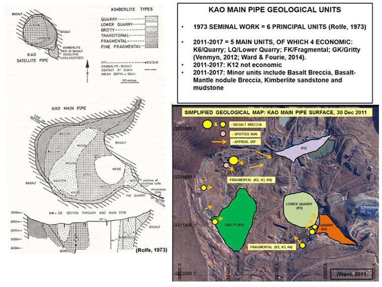
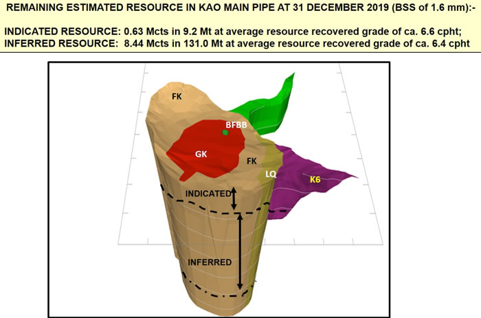
Using the previous borehole data drilled into Kao Main Pipe, mapping the mining pit as it has developed from the initial testwork pit in 2010 onwards through until today and supported by 3-D modelling of these data (Figure 3), SMD recognised 5 kimberlite units (domains/phases) of which 4 are currently economic, and one unit that post-dates the kimberlite volcanic activity. These kimberlite units and 1 non-kimberlite unit are summarised below in order of volcanic emplacement from youngest to oldest with further details provided in Table 1.
6. Central Basalt Breccia – not economic. Basalt dominated (>90%). Represents the post-kimberlite emplacement phases when basalt fell back into the then dormant open vent of the volcano.
5. GK Kimberlite (Gritty kimberlite) – economic. Fourth and last phase of kimberlite activity contained within in a smaller volcano nested in the next oldest, FK (Fragmental) phase. The size of this unit demonstrates that the kimberlite volcanic activity was waning through time, with the first event - K6 (Quarry) - the most violent, followed by diminishing intensity through LQ (Lower Quarry) and then FK (Fragmental).
4. K12 kimberlite – not economic. Not preserved in the actual Kao Main Pipe but in a north-east trending structural appendage off the main body. Related to the FK (Fragmental) Phase and therefore part of the third phase of kimberlite emplacement.
3. FK Kimberlite (Fragmental kimberlite) – economic. Third emplacement phase with multiple volcanic events. The LQ kimberlite forms a false footwall to FK along the eastern side of the pipe.
2. LQ Kimberlite (Lower Quarry kimberlite) – economic. Second emplacement phase which reamed out most of K6 from within the Main Pipe itself.
1. K6 kimberlite (Quarry kimberlite) – economic. First emplacement phase at a structurally-weak intersection of a west-north-west to east-south-east trending precursor kimberlite dyke and a north-east trending dolerite dyke structurally-weak zone. K6 is preserved only as a remnant wedge in a structural triangular cubby east-south-east of the Main Pipe itself.
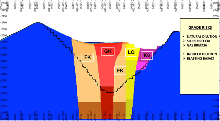
The setting of Kao Main Pipe and the resultant primary (kimberlite) diamond mine that has been developed by SMD at approx. 2,500 m above sea level in the Maluti Mountains is shown in Figure 3, along with a simplified 3-D geological model of the Pipe and these units. Figure 4 illustrates a west-east cross-section through the 3-D geological model, showing the structurally-controlled and preserved K6 wedge on the east-south-east side of Kao Main Pipe. The relationship of LQ as a false, non-basalt footwall to the subsequent FK intrusive phase is also clearly shown in Figure 4.
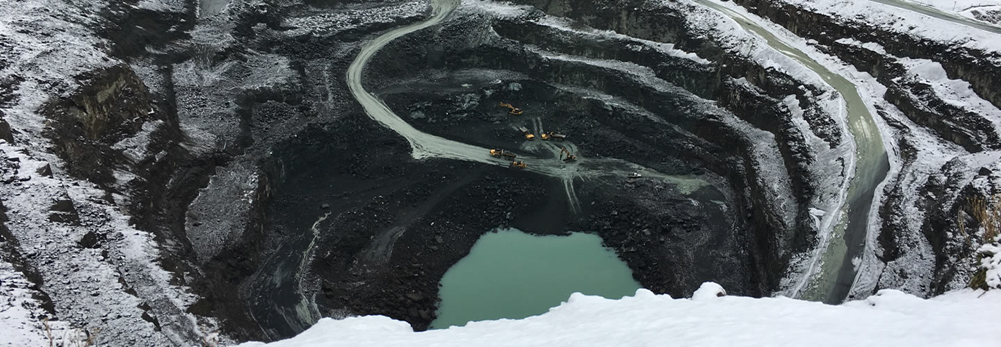
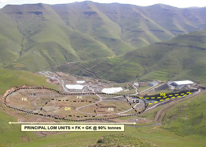
Figures 5 and 6 provide a comparative view of the Kao Main Pipe looking from south to north. Figure 5 shows the Main Pipe in February 2010, ahead of any major test work that extended over 2010 and 2011 before commercial production commenced in early 2012. In Figure 5, the surface expression of the 4 economic kimberlite units has been demarcated. Figure 6 illustrates the development of the Kao Main Pipe pit up until mid-2017.
Principal Geological Units Recognised in Kao Main Pipe
| Unit | GEOLOGICAL DESCRIPTION |
|---|---|
| K6 (Quarry; K6 of Rolfe, 1973) |
Initial main emplacement phase: pyroclastic to volcaniclastic (VK) kimberlite preserved in a structurally-controlled wedge off the south-eastern side of the Main Pipe. Two phases recognised: (i) K6(a) which is a darker, olivine-rich phase with abundant secondary pyrite that exhibits a higher grade (>20 cpht); this sub-facies is better preserved at depth within the K6 wedge; (ii) K6(b) conventional K6 with abundant thermally-altered basalt xenoliths, ilmenite, garnet and olivines; Recovered Resource Grade 16 - 19 cpht (BSS = 1.6 mm). Average stone size: 0.32 cts/stn. SG of hard material 2.68. |
| LQ (Lower Quarry; K5 of Rolfe, 1973) |
Second main emplacement phase: transitional to volcaniclastic (VK) kimberlite; preserved as a steep wedge abutting onto K6 within the Main Pipe; Abundant thermally-altered basalt xenoliths but poor in olivines, ilmenite. Recovered Resource Grade 4.5 – 5 cpht (BSS = 1.6 mm). Average stone size 0.24 cts/stn. SG of hard material 2.74. |
| FK (Fragmental, Transitional; Fine Fragmental K2, K3, K4 within Main Pipe of Rolfe, 1973) |
Third, and multiple, emplacement phase: largest volume of all of the Kao facies; mainly reworked volcaniclastic kimberlite (RVK) with abundant magmaclasts re-deposited back into the Main Pipe. Basalt breccias are interbedded with, and form part of, the Fragmental kimberlite re-deposition phase affecting grade adversely but generally hosting larger diamonds. Recovered Resource Grade 6 – 7 cpht (BSS = 1.6 mm). Average stone size 0.21 cts./stn. SG of hard material 2.39. |
| K12 (Fine Fragmental of Rolfe, 1973) |
Associated with early Fragmental emplacement: predominantly volcaniclastic kimberlite emplaced in structural protuberance off the northern side of the Main Pipe. Recovered Resource Grade 3 – 4 cpht (BSS = 1.0 – 1.5 mm). SG of hard material 2.39. |
| GK (Gritty; K1 of Rolfe, 1973) |
Last emplacement phase: pelletal-rich, volcaniclastic kimberlite with high garnet megacryst and mantle nodule xenolith content. Recovered Resource Grade 6 – 7 cpht (BSS = 2mm). Average stone size 0.20 cts/stn. SG of hard material 2.62. |
| CBB Central Basalt Breccia (NEW UNIT, Feb 2014) |
Re-sedimented, non-volcanic infill phase within the Main Pipe. Abundant, thick (>20 m) but spatially limited, cobble-boulder basalt breccia persisting down from surface to depth >300 m with subordinate RVK GK and FK fragments. No Recovered Resource Grade but predicted to be less than 0.5 cpht. SG of basalt 2.68 but of breccia 2.65. NOTE: This steeply dipping breccia deposit was hitherto enigmatic, but now interpreted as basalt talus/scree falling deep into the last open vent in GK. |
Minor Geological Units of KAO Mine Pipe
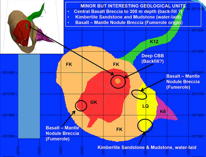
Although minor in comparison to the principal economic units of K6, LQ, FK and GK, there are a number of volumetrically small geological units within the Kao Main Pipe that locally affect grades negatively but which add to a better understanding of the complex character of this multiple phase volcanic intrusion. Some of these units are described briefly below (Figure 7 for their schematic position within Kao Main Pipe although pit mapping and borehole intersections have captured these features accurately in the 3-D geological models.
Apart from the more common talus basalt breccia deposits, one of the most interesting minor units is a basalt breccia that can be mapped from the current pit surface downwards for over 300 m in a near vertical borehole (Figure 7 insert). This “Central Basalt Breccia” (CBB) has hitherto been enigmatic but is best understood as a last stage back-filling from sidewall and surface processes gravitating basalt fragments back into a >1 km deep abandoned vent in GK. The grade is expected to be <0.5 cpht.
Fumerole activity is evident at several localities, affecting LQ, FK and GK units. The winnowing of the finer kimberlite is evident in basalt and mantle nodule rich breccias commonly cemented by calcite, natrolite and/or zeolite. In GK, garnet megacrysts are a common constituent in the matrix of these otherwise robust and coarse-grained deposits.
A small deposit of kimberlitic sand-sized grains (ripples) within a kimberlitic mudstone “pond” associated with a sidewall talus basalt breccia is a rare indicator of water-borne processes in this volcanic body where the LQ had been deeply and narrowly incised by mini-canyon like development.
Diamond Characteristics of the Principal Economic Kimberlite Units (Domains)
The overall diamond population in the Kao Main Pipe is above global average in both quality (65% gem, 8% near gem and 27% rejection) and average stone size (0.28 cts/stn). However, Kao produces about half the number of Type II diamonds, which is some 18% in +10.8 ct range, compared to Letšeng-le-Terae (Bowen et al., 2009).
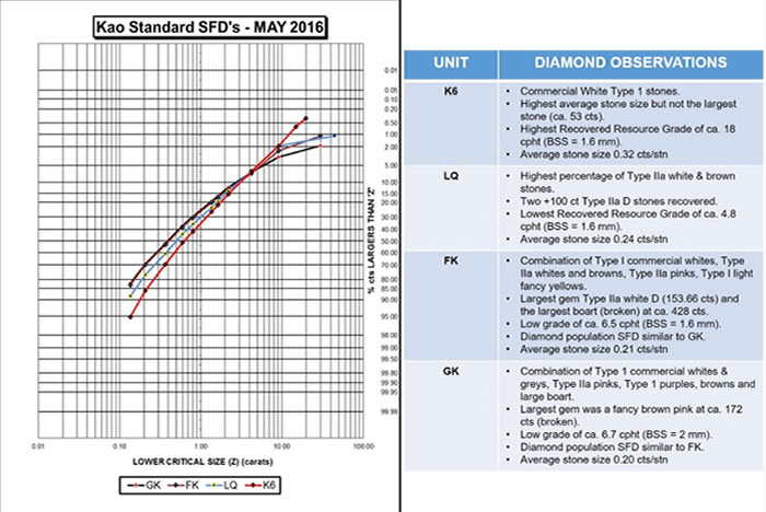
The four economic units, K6, LQ, FK and GK, display characteristic diamond populations which are further illustrated in their respective size frequency distributions (SFDs), although FK and GK are remarkably similar except in the larger sizes (Figure 8).
K6 has the highest recovered resource grade of the Kao economic units, running at 16 – 19 cpht (at BSS = 1.6 mm), as well as the highest average stone size (0.32 cts/stn) although it is not the host of the largest diamonds recovered from Kao. K6 is dominated by Type I commercial whites with high-yielding, octahedron to dodecahedron shapes (Whitelock, 1973).
LQ has the lowest recovered resource grade of 4.5 – 5 cpht (BS = 1.6 mm) but it hosts the highest percentage of Type IIa white (D-E) and brown stones having returned 3 X 100+ carat D stones to date.
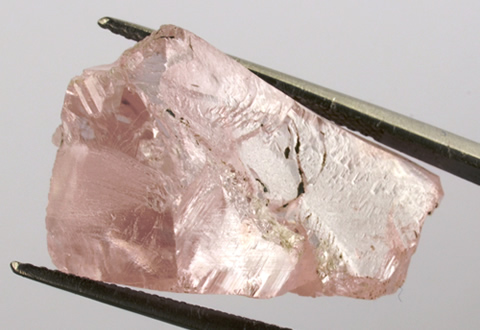
FK and GK have remarkably similar SFDs and grades and are also host to a variety of Type IIa stones, including Top Light Browns (TLB), fancy pink diamonds (up to 41 cts), as well as Type 1 fancy yellows (up to 30 cts) and Type I purple stones in GK (up to 28 cts). The largest diamond found to date, unfortunately in pieces with the maximum intact piece ca. 70 cts, has been an estimated reconstructed ca. 550 ct stone.
The high-value, “single special” stones, in particular the Type IIa diamonds that comprise about 18% of the +10.8 ct size range, contribute some 45+% of the revenue generated on the tender sales held 5-6 times a year in Antwerp. In general, the average revenue for Kao goods from these tenders runs between $250/ct to $350/ct, depending on the market and “single specials” numbers.
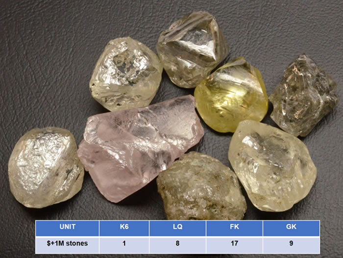
To date, 35 diamonds with values greater than US$ +1 million have been recovered from Kao Main Pipe between 2012 and 2019 (Figure 9). These values range from just over US$ 1 million to over US$ 15 million. The FK kimberlite has yielded the most US$ +1 million diamonds at 17 stones, followed by GK with 9, LQ with 8 and K6, the highest grade unit, with only 1.
Remaining Resource and Exploration Target for KAO Main Pipe (31 Dec 2019)
From the inception of the testwork first diamond results on the 10 May 2010 up until 31 December 2019 (Figures 10 and 11), the Kao Main Pipe has produced the following (approximately):-
- Stones Recovered: ca. 5.26 million stones (stn).
- Carats Recovered: ca. 1.50 million carats (cts).
- Tonnes Processed: ca. 27.6 million tonnes (t).
- Average Recovered Grade 5.4 cpht and average stone size = 0.29 cts/stn.
- Indicated Resource is estimated at some 0.63 million carats in about 9.2 million tonnes at an average recovered grade of around 6.5 cpht to approximately some 36 m below current mining levels;
- Inferred Resource is estimated at some 8.4 million carats in 131 million tonnes at an average grade of around 6.4 cpht from below the Indicated base level down to the end of the borehole drilling of some 500 m below original surface.
![]()